Planning the Search
How to plan a shipwreck search
This information is a simplified and shortened version of the Survey Plan and Report available from the Publications page
A large part of the search for the Whiting had been done by the time the geophysical survey was undertaken. A large amount of research in the archives found useful information about the ship, the sinking and what happened afterwards. This information could then be used to help plan the next step; the geophysical survey.
A geophysical survey uses remote sensing instruments to detect the remains of shipwrecks. Sonar instruments use sound to detect objects lying on the seabed or can be used to look in to the sand to see what lies buried. Other instruments can be used to measure the Earth's magnetic field and use that to detect iron objects.
When searching for any object on the seabed it is important to know something about the ship and what is likely to remain on the seabed. Given the search tools we have available and what their capabilities are we make a guess about what the wreck will look like using each instrument, and even whether we can 'see' the wreck at all. This information is used to formulate a search plan which is what we then do once we get out on the boat, it tells us what we need to do, how long it will take and how much it will cost to complete. Once the information is collected we can then process it all to come up with a list of Targets, interesting things on the seabed to dive on. After that we can put divers on to each Target and see if any of them may be the shipwreck we are looking for.
The instruments that we can deploy in the search include the magnetometer, side scan sonar and sub bottom profiler, these instruments are either fitted to or towed behind a boat which then runs a particular search pattern over the area of interest. The magnetometer is used to detect iron objects, the side scan sonar can detect objects lying on the seabed and the sub-bottom profiler can see into the sand to see objects that are buried.
Estimated Position
The first step is to work out a likely position for the wreck, this was done by adding all of the information available about the site to a computer generated plan using Site Recorder software. This software could be used to collect together information from maps, charts, stories and accounts into one place to get a more complete picture of what happened during the sinking, the events shortly afterwards and how the shipwreck site appears today. With all of the information in one place we could then get a good estimate of the position of the Whiting on the Doom Bar.
The accounts of the sinking of the Whiting say that she went ashore on the Ketch which is the most northerly part of the entrance to the channel into Padstow on the eastern side. The 1827 petition to the Admiralty says:
‘in September 1816 His Majesty's Schooner Whiting sunk in the western edge of the said Dunbar Sand where she now lies’.
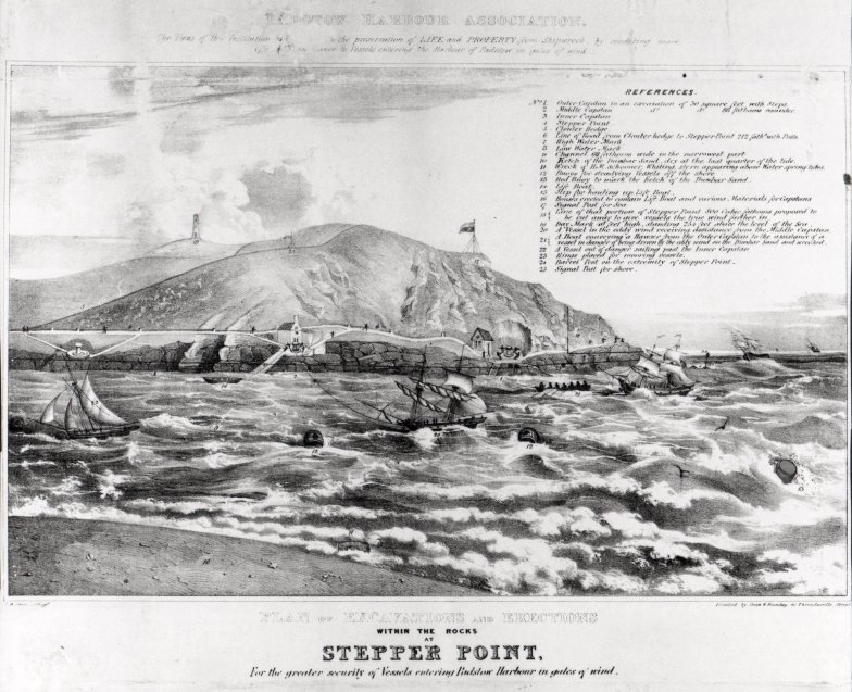
The lithograph or print from the Padstow Harbour Association shows the remains of the Whiting in relation to Stepper Point at the entrance to Padstow Harbour and the capstans and bollards they proposed to install.

Padstow Harbour Association Lithograph
The actual location of the capstans is shown on a later chart so could be added to the site plan. It was then possible to place the print onto the site plan in the correct position and orientation then a line was drawn on the site plan through the remains of Whiting shown on the print to the shore. As it was known that the ship went aground inside the channel on high water neaps, so a position along that line could be estimated on the plan.
Environment
The seabed of the Doom Bar consists of sand with rock outcrops close to the shore; the sand is easily moved by the tide but once settled it turns into a solid mass. The sand can move so much that the entrance to the harbour has moved since the time the Whiting was wrecked, originally it was close in to the rocks on the west side but now it is further to the east and the original channel has been filled in by sand. Northern part of Stepper Point consists of purple and pale green slate, the slate rock is not magnetic and should not adversely affect magnetometer survey work in this area.
Wrecking
HMS Whiting was wrecked on 15th September 1816 at the top of high water on a neap tide. The Whiting initially struck the Doom Bar head on but then swung round to the north with her bows toward the mouth of the harbour. With a heavy ground sea running she drove back onto the sand and hit the ground astern near the rudder. Attempts to haul her off the sand failed as the tide went out. Seven hours after going aground she was filled with water to within two feet of the lower deck showing that the hull was holed and was leaking. Pumping her out failed as the pumps choked with sand brought in with the water. Later on that day the hull completely filled with water, she fell over on her port side and she was later found submerged and with no-one aboard. The masts were cut away and stores were recovered from the vessel between 16th and 19th September. Salvage attempts between 20th and 22nd September failed but ended up pulling the hull over onto her starboard side, by then the vessel was heavily sanded in and buried. A subsequent salvage attempt by Capt. Ogders also failed.
Hull
The initial state of the Whiting hull is known from the records of her building:
Keel length 30m
Breadth 7m
Depth in hold 2.7m
Tonnage 225 tons
The vessel is built of wood, probably live oak, is fastened with wooden trenails. Iron was not used in her construction.
The Doom bar appears to provide a good preservation environment for wooden ships providing hope that some of the hull of the Whiting still survives. In March 2003 a section of timber hull appeared from the sand; the date of this wreck is not known but the wooden trenails that fasten the planks suggest this is not a recent sinking.
Any wood from the hull that has been exposed on the seabed for some time will have been eroded by the sand and eaten by animals that live in the sea so the hull may not be visible on the surface using the side scan sonar. The buried hull may be visible using the sub-bottom profiler.
Iron
The ballast is loaded in to the lowest part of the ship and is used as a weight to keep the ship upright. The weight and type of ballast used in Whiting is not recorded but iron ballast or kentledge was in common use at this time. A similar vessel, the United States Schooner Alligator built in 1820, carried 19 tons of iron ballast. For efficiency the ballast would be put as low as possible in the ship so would be difficult to recover from the Whiting once the hold had filled with sand, so is likely to still be on the Doom Bar.

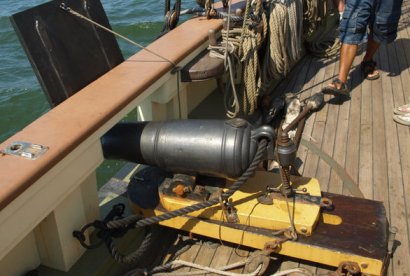
Carronade aboard Lynx
At the time of her loss the Whiting was fitted with 10 x 12lb short cannons (carronades) and 2 x 6 lb cannons. The carronades were shorter and lighter than ordinary guns and were designed for firing shot over short ranges. A carronade of this period that fired a 12lb shot was 2ft 8in (0.81m) long and weighed 6 cwt (304kg). A 6lb gun of 1782 could be between 6ft and 9ft long (2m – 3m) and weigh between 16cwt and 24 cwt (810kg to 1220kg). During the wrecking the guns were taken to the bows to help raise the stern off the Bar but there is no record of the removal of the guns from the ship. The quantity of shot for the guns on board at the time of sinking was not known but we do know she had four weeks stores on board. The court martial mentions ‘At low water people employed getting stores out of the hold and on shore’; the removal of shot is not mentioned but this could be covered by the term ‘stores’.
The Whiting probably carried three large Admiralty pattern longshank anchors 12 ft (4m) long and weighing 17 cwt (863 kg) plus a stream anchor weighing 6 cwt (305 kg) and a kedge anchor weighing 3 cwt (152 kg). The best bower anchor was used at the time she first struck and the cable connecting it to the ship was later cut attempting to escape. It is not known if the other anchors she carried were removed during the salvage, but they would be worth salvaging and as large, single items would be easy to recover. Therefore it is probable that they are no longer on site.
The majority of the mass of iron on the ship would be the ~19 tons of iron ballast as the total mass of guns would be approximately 5 tons. The ballast would be difficult to recover being in the lowest part of the hold, so if still in place the ballast could be detected as a ~20 ton magnetometer target.
Search Area
The search pattern will be a set of parallel runlines each a known distance apart so the vessel sails up one line, turns around then sails down another, collecting information as it goes. The primary search area has dimensions of 400m x 275m, heading 70º True. With a spacing between the lines of 10m this gives a total length of 11.2 km, so at 5 kt (9 kmh-1) this will take approximately 2 hours to complete.


