

Capstans and Bollards
All along the west side of the harbour mouth from Hawker's Cove to Stepper Point are the remains of bollards and capstans, left over from the time the harbour entrance was close to Stepper Point. In the early 1800's the loss of life and materials from shipwrecks on the Doom Bar was a cause of great concern so a group of people got together to help solve the problem. In November 1829 the Padstow Harbour Association for the Preservation of Life and Property from Shipwreck was formed with henry Price Rawlings as chairman.
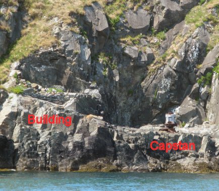
Remains of the outer capstan
The aim was for the association to install capstans and bollards on the landward side of the narrow channel entrance and place buoys on the seaward side of the channel. A vessel coming in to the harbour could be attached by ropes then be warped in safely between bouys and bollards.
The plan put forward by the association was shown in a lithograph. A wide road was built from Hawker's Cove to Stepper Point, three large capstans were installed on platforms near sea level and two mooring buoys were placed in the channel. In addition, a tall tower called a Daymark was built on Stepper Point so the harbour could be more easily identified by ships at sea.
Most of the installations are not visible from the coast path but from the sea its possible to get an idea of how the capstans worked. The middle capstan is in poor condition with just the central spindle remaining but the outer capstan is in a better state. The remains of a building shown on the lithograph can also be seen, this was used for storing materials for the lifeboat and capstans.
By following the coast path you eventually come to the 40 ft high Daymark that can be seen from 24 miles out at sea.
