
Wreck Site 3: Location and Surveys
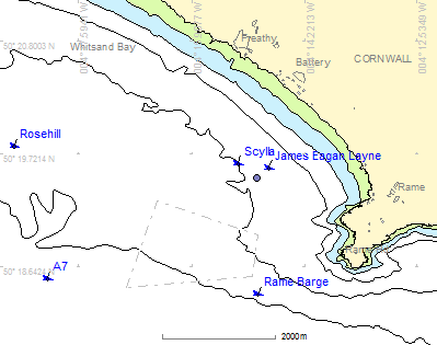 Chart of Whitsand Bay, East Cornwall
Today the wreck of the James Eagan Layne lies to the west of Plymouth on the sandy seabed of Whitsand Bay in Cornwall.
The wreck lies with her bow at 50° 19.602 N 004° 14.714 W and the stern at 50° 19.560 N 004° 14.773 W, approximately 1.2 km from the nearest land, 2.1 km north-west of Rame Head and 1.2km north of the Whitsand Bay dumping ground.
The bows are in 20m depth (LAT) and the stern is in 24m. The main part of the hull is 98m long with her bows to the north-east on a heading of 42° true, this section is intact from the bows to the bulkhead between hold #4 and hold #5. The stern section has broken away and lies some 30m away to the south-west.
Geophysical Surveys
One aspect of the Liberty 70 project has been to create a detailed site plan of the wreck using a combination of geophysical surveys, underwater photography as well as diver sketches and measurements.
Multibeam sonar data collected during previous survey work has been donated to the project by the University of Plymouth and the Royal Navy. Multibeam sonars produce detailed three-dimensional models of the seabed and wrecks which are at the correct size, position and orientation so are very useful for making site plans.
A plan view of the wreck from a multibeam sonar is shown on the left, the blue area is the seabed and the coloured area is the wreck with the red parts the shallowest. The white line shows the outline of the hull, holds and superstructure of the original ship. The small broken off stern section can be seen lying to the south-west of the main wreck.
The wreck will also be mapped using a high resolution multibeam sonar to obtain a more detailed 3D image of the site. This work will be undertaken by ProMare with the support of the University of Plymouth and a number of commercial organisations.
The wreck and the debris field around it have recently been mapped using both side scan sonar and magnetometer with the help of the University of Plymouth.
Side scan sonar surveys
A side scan sonar can be used to find and record objects lying on the seabed but can also give useful information about the texture and material that the seabed is made of.
A side scan sonar sends out sonar signals into the water and records their reflections from the seabed and any objects lying on it. The sonar is mounted in a towfish that is towed behind the survey boat on a long cable so the towfish 'flies' close to the seabed. Sonar signals are transmitted sideways from the towfish so the sonar can 'see' some distance either side of the boat. The towfish is connected to a computer on the boat that plots a picture of what the sonar can see as the boat moves along. Any objects showing proud of the seabed reflect the sonar signals and show up on the trace, taller objects also produce a sonar shadow behind them which can be used to estimate the height of that object. The images of the seabed from the side scan sonar can be stitched together as a single mosaic that covers the whole survey area making it easier for the surveyors to interpret what the images show.
_s.jpg) Deploying the sonar
Deploying the sonar
The picture below is a side scan sonar image of the James Eagan Layne as she was surveyed in March 2011. The image is a composite made up from a number of separate sonar images stitched together with the outline plan of the existing hull shown in white and the plan of the damaged stern hull plan shown in red. The darker area aound the hull is the shallow scour pit that has formed around the wreck due to the action of tidal currents. In the scour pit and around the hull can be seen debris that has fallen from the wreck. In the lower left corner is the broken off stern section connected to the main hull by a debris trail of wreck material. the position of each of the five cargo holds and the engine room is also overlaid on the plan.
The accurate position and orientation of the wreck and debris around from the side scan sonar survey has been used to help draw a detailed site plan of the remains of the James Eagan Layne. Further geophysical surveys will be undertaken in the near future so we can add more detail to the plan. Similar surveys will also be done later in the project and will be used to detect and measure changes that are happening to the site as the wreck itself falls apart.
Magnetometer surveys
A magnetometer was towed over the site while the side scan sonar survey was being undertaken. The magnetometer measures the Earth's magnetic field and can detect disturbances in the field caused by iron objects. The wreck itself is made of steel so bends the magnetic field over a big area, the aim of the survey was to record the shape of the ship's magnetic field as part of some research work we are doing on the use of magnetometers at sea. We could also use the magnetometer to help detect some of the smaller metal objects on the seabed around the site.
The picture below shows the survey lines run with the magnetometer and gives an idea of how the iron in the ship distorts the Earth's magnetic field. The yellow areas are undisturbed, the green areas are where the field is lower than normal and the red areas are where it is higher.
Smaller magnetometer targets were also detected around the site during the survey but are too small to be seen on the plot below. The positions of the targets have been recorded along with an estimate of the mass of iron in the target and eah will be investigated by divers in due course. Some of the smaller targets may be parts of the ship that were removed by salvors so can be identified and added to the site plan.
Other Wrecks
Other wrecks in Whitsand Bay include the Leander class frigate Scylla sunk in 2004 only 500m away, the armed merchant ship Rosehill torpedoed in 1917 4.5km to the west, the A7 submarine sunk in 1914 4km to the south west and the Rame Barge 2km to the south. All these wrecks are regularly visited by sports divers with the exception of the submarine A7 which is designated as a controlled site under the Protection of Military Remains Act and cannot be dived without special permission.
![]() If you can provide more information about this then please contact us.
If you can provide more information about this then please contact us.
